56K GENERAL INFO
Date: June 22, 2024
Start/Finish Location: Lake Siskiyou, south end of Box Canyon Dam
Start Time: 7:00 AM (6:00 AM early start)
Finish Cutoff Time: 6:00 PM
Headwaters Trail Runs is a cupless event. Runners will need to carry with them a water bottle, hydration bladder, collapsible cup or other means to receive drink aid at the aid stations.
56K REGISTRATION
Online registration closes: June 20, 2024.
In-person registration is available Friday, June 21st only at The Fifth Season (300 N Mt Shasta Blvd.) from 12:00 PM - 5:00 PM.
Day-of-race registration is not available.
In-person registration is available Friday, June 21st only at The Fifth Season (300 N Mt Shasta Blvd.) from 12:00 PM - 5:00 PM.
Day-of-race registration is not available.
|
Registration fees*:
|
Registration fee includes:
|
56K PRE-RACE T-SHIRT PICKUP
Pre-race t-shirt pickup and race info is available the Friday before the race from 12:00 PM - 5:00 PM at The Fifth Season store in downtown Mount Shasta City (300 N Mt Shasta Blvd.). Please note: All race bibs will be distributed to runners on race morning prior to the start of each race.
All race bibs and final t-shirt pickup will be at the start/finish area 6:00 AM - 6:45 AM.
Early starters race bibs and final t-shirt pickup will be at the start/finish area 5:30 AM - 5:45 AM.
All race bibs and final t-shirt pickup will be at the start/finish area 6:00 AM - 6:45 AM.
Early starters race bibs and final t-shirt pickup will be at the start/finish area 5:30 AM - 5:45 AM.
56K Awards & MEDALS
Top 3 overall female and male receive awards from our sponsors.
Top 3 female and male in each 10-year age group receive age group awards.
All finishers receive a finisher's medal.
Top 3 female and male in each 10-year age group receive age group awards.
All finishers receive a finisher's medal.
56K COURSE MAP & PROFILE
Due to persistent snow in Deadfall Lakes basin we will use an alternate course for 2024 which is approximately 32.5 miles with 8,000' climbing. Cutoffs are based on an average 20-minute per mile pace.
COURSE MAP:
COURSE MAP:
|
56k GPX FILE:
|
56k PDF FILE:
|
|
| ||||
56k ELEVATION PROFILE (approximately 7,800' total elevation gain):
56K AID STATIONS
There are four full aid stations and one water-only aid station along the 56k course. The distance between aid stations ranges from 2.0 miles to 7.7 miles.
Drop bags are only allowed at the North Fork Aid Station. Runners will pass this aid station twice and may access their drop bags both times.
Standard aid station fare will be provided, including sweet, salty, and savory snacks, gels, electrolyte drink, electrolyte capsules, and water.
Headwaters Trail Runs is a cupless event. Runners will need to carry with them a water bottle, hydration bladder, collapsible cup or other means to receive drink aid at the aid stations.
- RAINBOW RIDGE -Aid Station #1 Total mileage: 4.1 miles Distance to next: 7.7 miles Cutoff time: 8:25 AM Drop bags allowed: No Crew access: No Toilets: No Early starter's note: Please be aware this aid station may not be setup when you arrive. |
- NORTH FORK - Aid Station #2 Total mileage: 11.8 miles Distance to next: 4.7 miles Cutoff time: 10:50 AM Drop bags allowed: Yes Crew access: Yes Toilets: Yes |
- MT. EDDY -Aid Station #3 WATER AND GEL ONLY Total mileage: 16.5 and 18.5 miles* Distance to next: 4.7 miles Cutoff time: 1:15 PM (second visit) Drop bags allowed: No Crew access: No Toilets: No *1-mile before the Mt. Eddy summit turnaround and will be visited twice. |
- NORTH FORK -Aid Station #4 Total mileage: 23.2 miles Distance to next: 6.2 miles Cutoff time: 2:45 PM Drop bags allowed: Yes Crew access: Yes Toilets: Yes |
- DELTA -Aid Station #5 WATER ONLY Total mileage: 29.2 miles Distance to next: 2.9 miles Cutoff time: 4:45 PM Drop bags allowed: No Crew access: No Toilets: Yes |
- FINISH -Total mileage: 32.3 miles* Cutoff time: 5:45 PM *The 2024 alternate course is approximately 52k with 8,000 feet of climbing. |
56K RUNNERS CREWS
Crews may only assist their runners within 100 feet of the North Fork aid station.
Pacers are not allowed on the 56k course.
Driving directions to North Fork Aid Station (low clearance vehicles not advised):
Google maps link: https://maps.app.goo.gl/T2c3h97qkPdajCn98
DRIVING DIRECTIONS TO NORTH FORK AID STATION PDF:
Pacers are not allowed on the 56k course.
Driving directions to North Fork Aid Station (low clearance vehicles not advised):
- From the Headwaters Start/Finish, drive west on WA Barr Road for 5.5 miles.
- Turn right on Forest Service Route 41N53 (dirt, low clearance vehicles not advised), go 0.25 miles.
- Stay right at fork, continue on 41N53 for another 2.5 miles.
- Continue straight (right) on 41N53 for another 1.1 miles.
- Continue straight (right) on 41N53 for another 0.8 miles to North Fork Aid Station.
Google maps link: https://maps.app.goo.gl/T2c3h97qkPdajCn98
DRIVING DIRECTIONS TO NORTH FORK AID STATION PDF:
| driving_directions_to_north_fork.pdf |
56K DOG POLICY
Dogs are allowed to run the 56k course. If you choose to run with your dog, your pet is solely your responsibility. Please ensure that your pet is properly trained for the distance, and avoid putting her/him at risk. You must keep your pet leashed during the run, pick up after your pet, and respect other trail users. Runners with dogs must yield to those runners without dogs.
56k TRAINING RUNS
SATURDAY MAY 18, 2024
20.8-miles
We will run the entire 31k course from start to finish. The 31k course is the same as the 56k course without the 15-mile out-and-back section between North Fork AS and Deadfall Meadow AS.
This is a self-supported run - there will not be aid along the course. However, there is a reliable natural spring at about 10.1-miles. This is a natural water source - bring a water filter or drink at your own risk.
Saturday's meet-up instructions:
Meet at the Box Canyon Dam parking area at 8:00 AM.
Saturday's driving directions: https://maps.app.goo.gl/zLTAi5gqMDGW2ZQq6
Saturday Training Run GPX File:
| saturday_training_run.gpx |
SUNDAY MAY 19, 2024
15.0-miles
We will run the 15-mile out-and-back section between North Fork AS and Deadfall Meadow AS, then back to North Fork AS.
This is a self-supported run - there will not be aid along the course. However, there is a reliable natural spring at about 4.1- and 11.2-miles. This is a natural water source - bring a water filter or drink at your own risk.
Sunday's meet-up instructions:
1. Meet at the Box Canyon Dam parking area at 8:00 AM.
2. From the Lake Siskiyou Dam we will caravan to the North Fork AS about a 35-minute (13-mile) drive on rough forest roads. All-wheel or four-wheel drive is recommended. Low clearance vehicles are not advised.
Sunday's driving directions: https://maps.app.goo.gl/cqdBrdNk2agHq5Jd6
Sunday Training Run GPX File:
| sunday_training_run.gpx |
DRIVING DIRECTIONS TO START
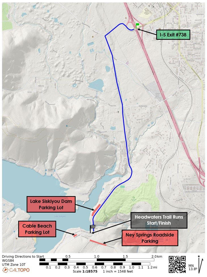
- From I-5 Exit #738, head west on W Lake Street toward W Jessie Street for 0.2 miles.
- Continue west on W Jessie Street/Hatchery Lane, go 0.2 miles.
- Turn left at the stop sign onto S Old Stage Road, go 0.2 miles.
- Veer slight right onto WA Barr Road, go 1.9 miles.
- Turn left into the Lake Siskiyou Dam Parking Lot just north of Box Canyon Dam.
- From Lake Siskiyou Dam Parking Lot walk 0.25 miles south across Box Canyon Dam to the race start/finish area.
- Additional parking is located at Cable Beach Parking Lot, another 0.4 miles past Lake Siskiyou Dam Parking Lot.
- Cable Beach Parking Lot is located southwest of Box Canyon Dam.
- From Cable Beach Parking Lot walk 0.25 miles east along Lake Siskiyou trail to the race start/finish area.
- Overflow parking is located along Ney Springs Road.
- From Ney Springs roadside parking, walk the road to Cable Beach parking, then 0.25 miles east along Lake Siskiyou trail to the race start/finish area.
Google maps link: https://maps.app.goo.gl/yh5o2TC5vvjyxbgC9
DRIVING DIRECTIONS TO START PDF:
| driving_directions_to_start.pdf |


